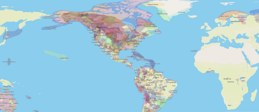
“Native Land Digital” is a provocative site based on the mapping of Indigenous territories projects patterns of seasonal use onto the fixed format of a map. It is both illuminating, colourful. But in other ways it is a trap that prevents us reimagining territory and space from an Indigenous perspective.
The “Native Land Digital” online map recasts the movement and mobility constitutive of many Indigenous hunting economies as fixed areas. Seasonality is lost. This shift from a lived time to the static temporality of a map recasts a diversity of hunting territories, fishing and food gathering sites as areas. Hunting territories were known through itineraries. From the 1700s in Canada, this included travel to and from and along trap “lines” that changed yearly to avoid depleting animal populations. Mobility, walking a storied space that is both memorial sites of a dreamtime and a space of everyday life is even more acute for the example of Australian Aborigines.
Unlike territorial nation-states, the coloured-in areas on the map overlap, sometimes concentrating at meeting points and at shared resources. More needs to be done with the questions of where is the map is most dense? When and how was it so in reality? And, why?
While the example here is a map of “native land”, it is fascinating that Europe, Asia and most of Africa are new “blank spaces” on the map. While we might think of Berber nomads as possibly Indigenous others to dominant groups and colonial settlers in North Africa; however, the map does not show “natives” for Europe except for Sami herders in Northern Scandinavia. Nomads such as the Roma also do not find a place in this representation – they cannot be mapped, which raises the importance of rethinking why and how historical Indigenous nomads are being mapped (and re-mapped, mis-mapped, and un-mapped) today.
For example, the map plots Inuit occupation over the entirety of the Arctic Archipelago in a manner reminiscent of claims of Canadian national jurisdiction and the province of Nunavut. But historically, occupation was neither seamless nor homogenous, especially in the very high latitudes of the “High Arctic.” This likely reflects an southern image of Inuit land occupation.
The map is a “space of representations”: historically constantly updating the territories of the king or of a landowners is an obsessive colonial gesture of territorial acquisitiveness and avarice.
-Ancient colonial maps have been taken up in wallpaper as a fascinating form of domestic decor.
-The legacy of mapping today is to continue to represent the world as a territorialised spatialisation of areas linked to particular cultural groups. A sort of ethnonationalism links cultures to territories.
-In digital form, it includes the trope of animated zooming in to abstract ethnic and legal territories and to language territories that links the global overview scale to particular regions and to shaded representations of material topographies that lend an aura of realism to the abstract elements.
-Rob Shields (University of Alberta)